 |
This map project on the Roads and Trails of Colonial America started by questioning what routes the immigrant ancestors used during their southern and western migrations. The assumption was that our earliest immigrant ancestors were limited to the waterways which accessed the coast and an occasional Indian path. And for the most part, that was true, However, further research proves that the Native population used trails and routes extensively to travel and trade throughout the hinterland and even to the coast. The challenge was for our early ancestors to identify the many routes and survive the journey.
|
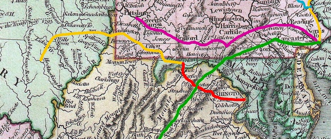
1. The Conestoga Road (c. 1711)
The Conestoga Road was the first section of the future Great Wagon Road. Starting at Market Street in Philadelphia, the Conestoga Road (in green) ran northwest below the Schuylkill River then southwest through Paoli and then Coatesville and then west to Lancaster (US 30. The original Conestoga Road continued west to Columbia where, eventually, a ferry crossed the Susquehanna River.
Picking up the trail on the west side of the Susquehanna, the Great Wagon Road ran west and south through Maryland to the Potomac then up the Valley of Virginia. At Roanoke VA the road branched south to the Carolina Piedmont and then down to Ft. Augusta GA.
In 1711, settlers from the Palatinate of the Rhine, who were led by Bishop Hans Herr, traveled down the Conestoga Road to the Conestoga River and then up Pequea Creek in what would become Lancaster Co PA and established the first settlement on the western frontier of Pennsylvania.
Continual improvement over time widened this first section of the road to allow the namesake Conestoga Wagons to traverse the route, transporting people and goods to the west in comfort. Crossing the Susquehanna River at Columbia PA, the Great Wagon Road provided access to the interior and America's manifest destiny.
2. The Bethlehem Pike (1740)
Traveling north and south in far eastern Pennsylvania was always possible by way of the Delaware River. But, not everything can be transported by boat. And, there were always Indian paths.
As early as 1740, settlers of Colonial Pennsylvania were traversing an Indian path north from Philadelphia to the Lehigh Valley. And as traffic increased, the road was widened. Later, the road became know as the Bethlehem Pike (in yellow) and was maintained by local municipalities.
3. Owen's Road (1787)
After the initial settlement of Philadelphia and then Germantown, our ancestors migrated north, up the Delaware Valley, looking for new lands. And in the next generation, the same families had their eyes on the western frontier in the Susquehanna Valley. How would they get there?
In 1769 Evan Owens speculated on lands along the Susquehanna north of Harrisburg. Departing Harris Ferry (Harrisburg) the party traveled upriver by way of a "Durham" boat to the Nescopeck Falls and then by canoe to the Fishing Creek Valley. Owens liked what he saw and purchased the land. But due to Indian hostilities, Owens did not return until eight years later in 1780 when he settled the town of Berwick PA.
With the land purchased and a new town staked out, how would Owen get settlers to the Fishing Creek Valley? Rowing up the Susquehanna with family, possessions, and livestock wasn't an option. The answer was a new road. Ergo, Owen's Road (in light blue).
The first road through the township was the old blind way, known to be used as far back as 1800 and called the Owens road, built by Evan Owens in 1786 from Berwick to Mauch Chunk, which passed through William Seiwell's farm. Soon after 1804 a force was at work building the old Lehigh & Susquehanna turnpike, that is now the road passing through the village of Conyngham. . . ."Sugarloaf Township," History of Luzerne County, Pennsylvania, 1893 <http://www.usgwarchives.net/pa/luzerne/1893hist/sugarloa.htm> 28 November 2014.
The following year (1792 in all probability) the actual immigration occurred. The route pursued was the Susquehanna and Lehigh road from Easton to Nescopeck falls [PA 93], laid out by Evan Owen in 1787. . . .(225-226)"History of Columbia and Montour Counties Pennsylvania (1887)," Columbia Co PA GenWeb Site <http://www.pagenweb.org/> 15 November 2014.
The first indications of settlement and improvement in Briarcreek township became apparent about this time. A number of families removed from mount Bethel, Northampton county, near the Delaware river. . .They emigrated in a body and entered the region in 1793, journeying by way of Bethlehem, Nazareth and Beaver Meadows. (p. 193)
"Historical and Biographical Annals of Columbia and Montour Counties, Pennsylvania" <http://books.google.com/books> 23 November 2014.
4. Forbes Road (1758)
In the 1730s, the western frontier of Pennsylvania was the Susquehanna River at the Lancaster settlement. By the 1750s, another road was cut toward the frontier from Germantown, north of Philadelphia. The old Germantown Pike wound west through the Berks county settlements, extending west through Lebanon and then down to Harris Ferry (Harrisburg) on the Susquehanna River. And with the ever continuing westward expansion during Colonial America, new settlers breached the boundary at the Susquehanna and headed west to the Alleghenies. But, there were no roads. Again, Indian paths became roads.
In 1758 after the failed Braddock's campaign from western Virginia to the Forks of the Ohio, British General Forbes and the Pennsylvania Militia, a truly superior force including cannons, built their road west to Ft. Duquesne. The army crossed the Susquehanna at Harris Ferry and assembled at Carlisle on the west bank. From Carlisle, the new road followed the old Indian path southwest to the base of the Alleghenies at Ft Raystown (now Bedford) then up through the mountains west to Ft Ligonier and then west to Ft. Duquesne.
The first Battle of Ft Duquesne was a terrible failure; as Col Grant and his Highlanders were slaughtered by the French and their superior Indian allies. However, Forbes' army, which had been reinforced by the Virginia Regiments and Col Washington, marched on the fort. In advance of the arrival of the British and Americans, the French withdrew, burning the fort when they left. With the departure of the French, Pennsylvanians and Virginians were left behind to rebuild and garrison the new Ft Pitt.
Forbes Road was also called the Raystown Path or Old Trading Path. Forbes Road was a widening and improvement of an older trading path to make a military road under the leadership of British Brigadier General John Forbes during the French and Indian War. His goal was to cross the Appalachian (Allegheny) Mountains with heavy artillery and an army large enough to repel French forces at Fort Duquesne in what is now Pittsburgh on the Ohio River. General Forbes' men constructed the road in 1758 from Carlisle, Pennsylvania to Fort Duquesne, connecting Philadelphia to Pittsburgh. The road from Carlisle to Fort Duquesne was about 200 miles (322 km)."Forbes Road," US Migration Trails and Roads <https://familysearch.org/learn/wiki/en/Forbes_Road> 20 November 2014.