 |
This map project on the Roads and Trails of Colonial America started by questioning what routes the immigrant ancestors used during their southern and western migrations. The assumption was that our earliest immigrant ancestors were limited to the waterways which accessed the coast and an occasional Indian path. And for the most part, that was true, However, further research proves that the Native population used trails and routes extensively to travel and trade throughout the hinterland and even to the coast. The challenge was for our early ancestors to identify the many routes and survive the journey.
|
1. Accessing the American Interior
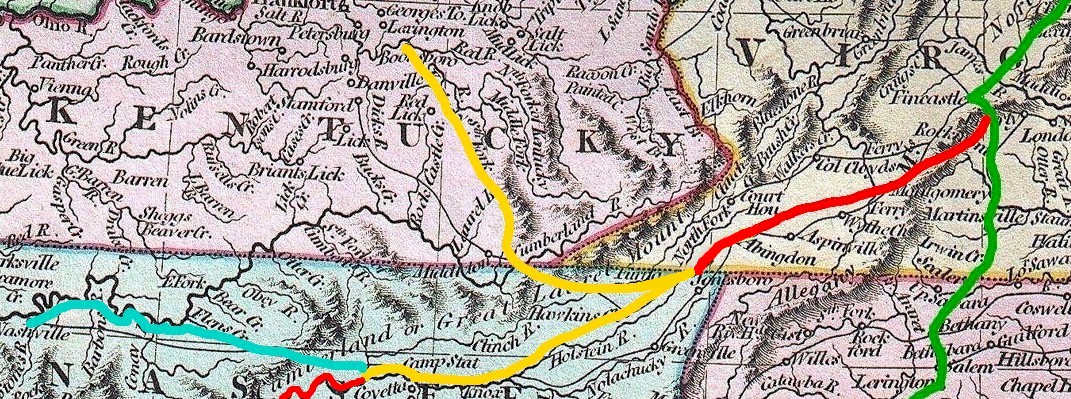
Settled before the end of the Revolutionary War by the Over-the-Mountain Men, the American interior, west of the Appalachians, was accessible by way of the Valley Road (in red) down to the Wilderness Road (in yellow). The northern branch of the Wilderness Road led up through the Cumberland Gap to the interior of the future State of Kentucky, and the southern branch led down the Holston to the interior of the future State of Tennessee.
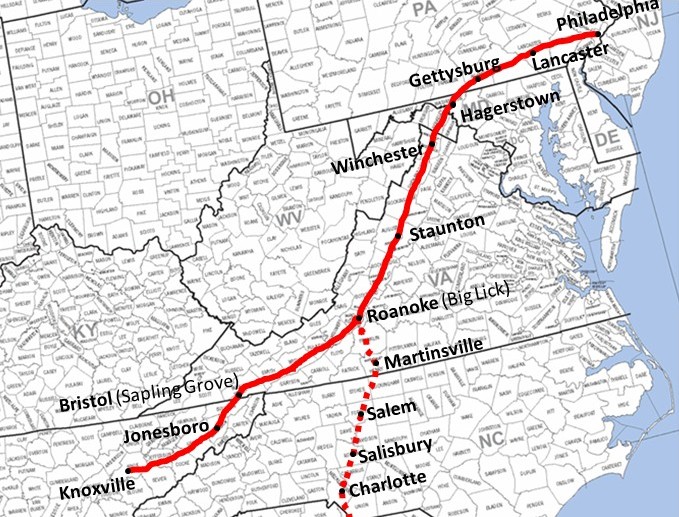
By 1765 the Great Wagon Road, running from Pennsylvania to Georgia along the Blue Ridge Mountains, was improved to accommodate wagons. Traveling south up the Valley of Virginia. the road rose up to the headwaters of the James River at Roanoke VA. Here the road split. The western branch, known as the Valley Road, descended southwest into the New River Valley. And, the southern branch continued on to the Piedmont of North and South Carolina, descending to Ft. Augusta GA on the Savannah River.
Great Valley Road also called in various parts the "Great Wagon Road," "Great Warriors' Path," "Valley Pike," "Carolina Road," or "Trading Path," was the most important Colonial American route for settlers of the mountainous backcountry of the southern British colonies. It went from Philadelphia, Pennsylvania over to the Shenandoah Valley of Virginia, forking into the Tennessee Valley and Knoxville. The other fork went more south into the Piedmont Region of North Carolina and then to its terminus on the Savannah River at Augusta, Georgia. From Philadelphia to Augusta was 735 miles (1183 km).
Great Valley Road, Family Search <https://familysearch.org/learn/wiki/en/Great_Valley_Road> 12 November 2014.
2. The Valley Road (1765)
The Valley Road began at Roanoke VA past the headwaters of the James River:
-Turning southwest, the road led up to the headwaters of the Roanoke and then downhill into the New River Valley.
-Continuing southwest, the Valley Road rose up to meet the headwaters of the New River which flows north to meet up with the Kanawha en route to the Ohio at Point Pleasant (W) VA. Here, Ft. Chiswell stood as a bastion against marauding Indians. By 1775 this was the end of the road.
-Were you to continue uphill, you would enter a pass (vic. Atkins VA) where the path begins its descent to the Holston.
-Continuing down the Holston, the land begins to open up and the path leads to the current Virginia/ Tennessee boarder (vic. Bristol VA). But, the settlers didn't know that; as the first settlers believed they were part of the abortive Colony of Transylvania.
-And, the path continues southwest down the Holtson to its confluence with the French Broad to form the Tennessee River near Knoxville TN.Research note: In 1772 early settlers formed the extra-legal Watagua Republic. In 1776 the residents in the lower Holston Valley petitioned for organization as a county of Virginia which was declined. In 1777 North Carolina organized the western settlements in the lower Holston as Washington County. And from 1784 to 1788, these western lands seceded from North Carolina to form the unsuccessful State of Franklin.
The entire road, from Knoxville TN up through the Holston Valley then down through the New River Valley then down through the Shenandoah Valley and beyond has been called the Valley Road. Perhaps, the name depended on what section of the road you were on and when. My use of the term Valley Road is to differentiate the section of road which splits off the Great Wagon Road at Roanoke VA from the main road which continued down through the Carolinas to Georgia.
|
|
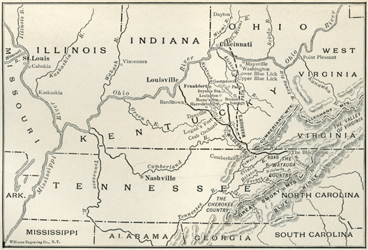
3. Daniel Boone and the Wilderness Road (1775)
In 1775 Daniel Boone of the Yadkin Valley of North Carolina was hired by Richard Henderson of the Transylvania Company to blaze a trail from Ft. Chiswell (now Wytheville VA) down the Holston and then up the Cumberland Gap to the interior of what is now Kentucky. The Transylvania Company illegally purchased much of central Kentucky and eastern Tennessee from the Cherokees, who didn't "own" the land, with the intent to establish a new Colony of Transylvania. And, Boone was in on the deal.
The north branch of the Wilderness Road was blazed by Daniel Boone in 1775:
-Starting at Ft. Chiswell, Boone followed the path up into the gap and then down to what is now Bristol VA.
-From Bristol, Boone continued west to the headwaters of the Holston River at what is now Kingsport TN.
-From Kingsport, Boone started northwest, up and over to the Clinch River Valley.
-Then down the Clinch, west to the Cumberland Gap (vic. Middlesborough KY).
- Daniel Boone continued up through the Gap into the heart of Kentucky, founding the town of Boonesborough, the designated capital of the Colony of Transylvania.
|
|
4. Populating the Interior
Success breeds success. One of the onerous British rules prior to the Revolution was the prohibition of settlement west of the Appalachians. But with the onset of war, the "lid" was lifted off the boiling pot of westward migration. Even as the Revolution was raging, settlers were pouring down the Great Wagon Road then down the Valley Road to the intersection with the Wilderness Road heading for Kentucky and Tennessee.
Before Boone, the road ended at Ft. Chiswell VA. Afterwards, the settlers were not just grizzled mountain men and "long hunters." Instead, our Over-the-Mountain Men brought their wives and children and household goods and livestock, looking for new lands to settle. And as traffic increased, the path was widened.
From Roanoke, settlers with all their possessions and wagons had easy access down the valley toward Tennessee and Kentucky. However at the new end of the road (vicinity Bristol VA), the Wilderness Road narrowed into a horse path. Reportedly, the settlers had to dump their possessions and try to sell their wagons to proceed to the hinterland.
Either at Bristol or a little further west on the Holston in the vicinity of Kingsport TN, the Wilderness Road split. The north branch, which was Boone's original trail to the Cumberland Gap, went north into Kentucky. And, the south branch of the Wilderness Road ran next to the Holston River toward Knoxville TN where the Holston joined the French Broad to form the Tennessee River.
The Wilderness Road, opened in 1775 into central Kentucky, and branched off the Great Valley Road in southwest Virginia at Bristol (Sapling Grove). . .From the terminus of the Great Valley Road at Knoxville, Avery's Trace to Nashville opened in 1788, and the Georgia Road to Athens opened in 1805.
Great Valley Road, Family Search <https://familysearch.org/learn/wiki/en/Great_Valley_Road> 12 November 2014.
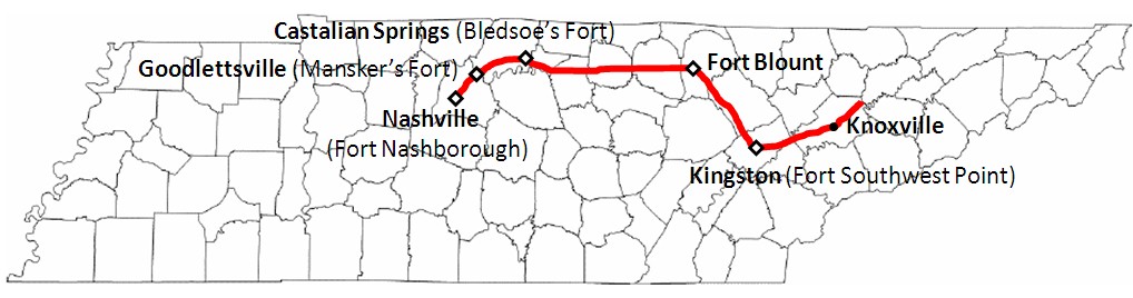
5. Avery's Trace to Nashville c. 1788
In 1787 the North Carolina Legislature authorized creation of a road to the settlements on the Cumberland River. In 1788 Avery's Trace (or the Nashville Road) was opened:
-From Clinch Mountain west of Kingsport and at the junction with the Wilderness Road, Avery's Trace followed the Holston River southwest, downriver to Knoxville at the confluence of the Holston and the French Broad Rivers and the beginning of the Tennessee River
-From Knoxville southwest down the Tennessee to Ft. Southwest Point (now Kingston) TN and the confluence with the Clinch River
-From Ft. Southwest Point northwest to Ft. Blount (vic. Gainesboro) TN on the Cumberland River
-West down the Cumberland to Ft. Bledsoe (vic. Castalian Springs) TN
-West to Ft. Nashboro (now Nashville) TN.
|
|
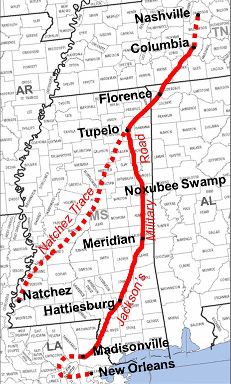
6. Jackson's Military Road c. 1820
Traveling southwest from Nashville TN, Jackson's Military Road, constructed 1816 to 1820, wound south to Columbia TN then southwest to Muscle Shoals AL where it crossed the Tennessee River. Following the old Natchez Trace, the road went again southwest to Tupelo MS where it picked up the Tombigbee River. Heading south, the road followed the Tombigbee to Columbus MS. Here the road went south, crossing the Noxubee Swamp toward Meridian MS and then Hattiesburg MS and then south again to Madisonville LA on the north shore of Lake Pontchartrain, just across from New Orleans.
Research note. Jackson's Military Road went out of use; as failure to repair the corduroy roads across the swamp made the road impassible.Jackson's Military Road has been cited as a primary route south to lower Mississippi. But it wasn't; as the road wasn't completed until 1820 and almost immediately fell into disrepair. The earlier Gaine's Trace which intersected the Three-Chopped Way at Ft. Stephens AL and wended up the Tombigbee River to the Tennessee, was one of the routes open during the period of "Mississippi Fever."
|
|