 |
This map project on the Roads and Trails of Colonial America started by questioning what routes the immigrant ancestors used during their southern and western migrations. The assumption was that our earliest immigrant ancestors were limited to the waterways which accessed the coast and an occasional Indian path. And for the most part, that was true, However, further research proves that the Native population used trails and routes extensively to travel and trade throughout the hinterland and even to the coast. The challenge was for our early ancestors to identify the many routes and survive the journey.
|
Back before the Revolution, frontiersmen could walk from the Carolinas to New York on the old Indian path called the Warrior’s Path. This path ran east of the Appalachians down through the Valley of Virginia and up through the Susquehanna Gap into western New York. With American expansion west from the coastal regions, settlers found their way down the path into the hinterland.
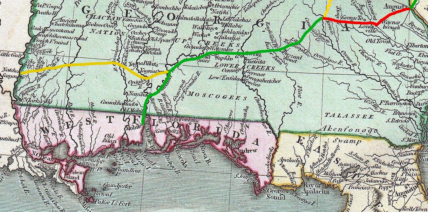
A large section of the old Indian path became what we know as the Great Wagon Road which ran south from Lancaster PA, up through the Valley of Virginia, across the Up-country of North and South Carolina, down to Ft. Augusta GA. Thus, America's first interior roads were Indian Paths. [Map of the Great Wagon Road]
After the Revolution and before the War of 1812, several Indian paths led from the Upcountry of the Carolinas down to the Tennessee River and then down to Mississippi. Additionally, following the Great Wagon Road, settlers from the Carolinas moved south into Georgia. But, there were no available paths from eastern Georgia through Alabama to Mississippi; as this was Creek Indian lands.
By 1805 the Great Wagon Road was well established including way-houses and stage-coaches. Migrating south to Georgia would have been fairly comfortable. But once across the Savannah River, things changed. Georgia had few roads and little infrastructure. The road from Augusta, the southern terminus of the Great Wagon Road, to the new Capitol of Milledgeville would have been arduous at best. And, conditions went downhill from there.
As the US Government now controlled the new Mississippi Territory--Alabama and Mississippi--there was a need to connect the settlers of eastern Georgia going west to the settlements of Mobile Bay and the Tombigbee River and the settlements of the Natchez District of old Spanish Florida (now Mississippi). But in the first decade of the 1800s, there wasn't an Indian path which headed directly toward Mississippi which they could follow. Of note, we know there were Indian paths; as the Creeks had settlements at old Muscogee and Coweta on the Chattahoochee River. Heading west, the challenge was to connect Milledgeville to the Chattahoochee River and the Creek Indian paths. And heading east, the challenge was to connect the new settlements in Mississippi west of the Pearl River to the Tombigbee River and Mobile Bay in Alabama.
So in 1807, the US Army forged a trail west from Milledgeville GA and east from the Pearl River in Mississippi. We know that the western section of the road was marked by three blazes of an ax on a tree. Thus, the Three-Chopped Way was born. It is not certain that the remaining section of the road heading all the way to Milledgeville GA was marked in a similar manner.
Wars make roads essential. Therefore by 1813, the Army widened the section of the road from Milledgeville GA heading west to Ft. Stoddert AL at Mobile Bay so that wagons could traverse the path. And, the improved section, named the Federal Road, eventually extended all the way to New Orleans.
Later, the section from Natchez MS through Monticello MS through Winchester MS to St. Stephens AL, including the shortcut through Ft. Claiborne AL to the intersection with the improved Federal Road at Burnt Corn AL was upgraded to accept wagons. And with the improvements, the old Three-Chopped Way was renamed the Post Road; as the US Mail traveled every three weeks west from Georgia to Mississippi.
A couple of family stories:
1. Samuel Varnadoe of Orangeburg Co SC. (an in-law of my Hutto family)
Summary: The journey to Mississippi Territory was made over poorly-marked footpaths through Indian-occupied territory during the winter months. River crossings were especially troublesome. Samuel Varnadoe and his family made the journey in 1811. Richard and Ann Simmons followed in 1812.Samual Varnadoe heads west. There is little in the family traditions about the journey from South Carolina. We know when Samuel Varnadoe made the journey because until 1830, when Congress passed a bill abolishing the Indian nations east of the Mississippi River, the Choctaw and Creek Nations were technically foreign countries. When the US government recognized these so-called Civilized Indian Nations in 1786 it assumed the responsibility of regulating those American citizens living or traveling in the Indian nations. US citizens traveling to Mississippi Territory from the eastern states were required to have passports. The Varnadoes obtained their passports from a judge in Jones County, Georgia. The two elder sons of Samuel Sr. held passports issued in October 1809. A younger son, who accompanied his father to Mississippi, got a passport in March 1810. A year later Samuel Sr. was issued a passport for himself, his wife, his seven children and two slaves. Samuel's group followed the others to Mississippi in the spring of 1811.
The trails leading west. I have no knowledge of the route they took to get to Mississippi. However there were very few roads into the Mississippi Territory in those days so it is possible to make a reasonable guess. The very earliest settlers from both the Carolinas and Georgia came down the Cumberland River on rafts, got onto the Mississippi River and floated down to the village of Natchez. From there they walked the remaining sixty or seventy miles to what became Amite and Pike Counties.
Later settlers from Georgia would begin their journey on the Federal Road that originated in Macon, Georgia. This road ran past where the cities of Columbus and Montgomery are today and then turned southwest to New Orleans. Close to what was later Fort Claiborne, at a place called Burnt Corn Springs, a wagon road called the Three-Chopped Way branched off to Natchez. This trail roughly paralleled the present US Highway 84. After ferrying the Alabama River at Fort Claiborne about 65 miles north of Mobile the road proceeded to Fort St. Stephens on the Tombigbee River, a distance of 25 miles. From Fort St. Stephens the road ran westerly for 150 miles until it crossed the Pearl River near where Monticello, Mississippi, is today. . . .
"The Ancestors of George and Hazel Mullins," <http://www.georgemullins.com/chapter04.htm> 9 November 2014.2. Samuel Lee of Robeson Co NC:
In 1808 a Samuel Lee received a passport from the Governor of Georgia to pass through the Creek Nation to Mississippi. As there are no other records at this time for Samuel Lee until his arrival in Wayne Co MS, this could mark Old Sam's migration to Mississippi.
The three possible routes which the Lee family could have taken from North Carolina to Mississippi are:
1. By sea from the Carolina coast around Spanish Florida to the ports on the Spanish Gulf Coast.
-Note: Spain was a hostile foreign power who worked with the British to undermine American expansion in Georgia and the new Mississippi Territory. Spanish West Florida (southern Mississippi east of the Pearl River and southern Alabama including Mobile Bay) was occupied by the US Army during the War of 1812. The remainder of Spanish Florida was ceded to the US in 1819.
-The Lees could have gotten in a canoe just down the road from their homes and rowed down the Lumber River to Lumberton on the North Carolina coast.
-Awaiting transport, sometime later you boarded a sloop bound for southern Florida. As your intention was the Spanish Gulf Coast, you probably had to change boats to reach your destination, probably in Havana, Cuba.
-If you survived Havana, the next sloop would sail northwest into the Gulf of Mexico for the Spanish Gulf Coast.
-Arriving on the Spanish Gulf Coast, you would probably have had to swear allegiance to the hostile foreign Sovereign of Spain; as any lands accessible by water from the Spanish Gulf Coast were claimed by Spain.
-Having been dumped ashore near Pascagoula, Spanish West Florida, you probably had to build your own boat/raft.
-Rowing up the Pascagoula River, you passed out of civilization and into an unoccupied wilderness.
-The river splits vicinity Merrill MS. To the left is the Leaf River. To the right is the Chickasawhay River. Which fork do you take?
-Were you to survive the trip up the Chickasawhay River, the first civilization you would have met would have been the intersection of the Three-Chopped Way and the river at Winchester MS.2. By land west to Tennessee then southwest to Mississippi.
-There were two routes west out of North Carolina to Tennessee.
-The northern route would have gone all the way up the Great Wagon Road to vicinity Roanoake VA and then down the Wilderness Road and the Holston River into Tennessee.
-The southern route would have gone west to the Catawaba Valley then northwest up the Catawaba Trail to the Tennessee River.
-At the Tennessee River, the route wound south down the river into Alabama vicinity Florence AL where you pick up the Gaines' Trace.
Note: Gaines' Trace wasn't blazed until 1810; However, an Indian Path already existed.
-Continuing west on the Tennessee River to the Tombigbee Gap, the route winds south along the Tombigbee River down through northern Mississippi and then Alabama to St. Stephens AL where the Gains Trace intersected with the Three-Chopped Way.
-And from St. Stephens AL, the route wends west to Greene Co MS.3. By land south to Georgia and then west to Mississippi.
-As previously stated, migration south from North Carolina to Augusta GA on the Great Wagon Road would not have been a problem. But once across the Savannah River, conditions were worse.
-From Augusta south to the new Georgia Capitol at Milledgeville, the roads were bad but passable.
-We know that the Three-Chopped Way was blazed in 1807. As the road was only one-year old, it probably was rough. I doubt Sam Lee could have taken wagons down the road. Therefore, the Lees would have sold their wagons in Georgia and saddled-up horses and mules for the arduous trek west to Mississippi.But, I think the Three-Chopped Way was the most practical route. And, I believe that’s how my Lee family got from North Carolina to Waynesboro MS. Of note, my Lee family settled atop the bluff west of Waynesboro MS where the Three-Chopped Way crosses the Chickasawhay River.
Natchez Trace. The earliest and the most famous of the public highways which traversed the present State of Mississippi was the so called Natchez Trace. . .the Federal authorities empowered General Wilkinson [1801 [to open] public roads and mail routes, from the settlements of the Natchez District, to the frontier settlements of Tennessee and Georgia. . .over the lonely Indian trace which led for five hundred miles through the lands of the Choctaws and Chickasaws. . . .
The Natchez Trace crossed the Tennessee river a few miles below the Mussel Shoals, at "Colbert's Ferry," and thence pursued a southwesterly course through the country of the Chickasaw's and Choctaw's, to the "Grindstone Ford," on the Bayou Pierre; thence ran south and west to Natchez; South of Natchez, we have already seen that it followed the general trend of the river to the line of demarcation; it eventually connected with the various roads leading to New Orleans. . .The total distance to Nashville was 501 miles. . .Undoubtedly, the road through the Indian country in Mississippi was once the old Indian trail leading southwest to the Mississippi river.
Natchez to Fort Stoddert. There were three important roads, or horse-paths, which traversed the vast expanse of the Mississippi Territory, during the first few years after its organization.
-First, the road from the Cumberland settlements through the Chickasaw and Choctaw nations to the Natchez District, and known as the Natchez Trace, (Vide ut Supra)
-second, the road from Knoxville through the Cherokee and Creek nations, by way of the Tombigbee, to Natchez [Gaines' Trace].
Research Note: Jackson's Military Road went northeast through the Creek and Chickasaw nations and was completed in 1820. The earlier Gaines' Trace intersected the Three-Chopped Way at Ft. Stephens AL and wended up the Tombigbee River to the Tennessee.
-third, the road from the Oconee settlements of Georgia, by way of Fort Stoddert [on Mobile Bay], to Natchez [Three-Chopped Way/ Post Road] and New Orleans [Federal Road].
While the first of these roads was the most frequented, the third is important because it first bridged the eastern and western parts of the Territory. In the summer of 1807. . .[the task was to] view, mark, and open a good road on the nearest route from the city of Natchez to Fort Stoddert so as to intersect the new Creek road on the line of demarkation east of Pearl river. This was the first road from Natchez to St. Stephen's. . .On the 7th of December following, public notice was given [traveling east to west] that the ferry is now complete over the Alabama river, above Little river, and on the Tombigbee, just above Fort St. Stephen. [The logical intersection would have been at Burnt Corn AL] The way is now completely opened and marked with causeways across all boggy guts and branches, so that strangers can travel the road with safety, by observing the three notches, or three-chopped way, which cuts off a great distance in traveling from Natchez to Georgia. This was the first road opened from the western to the eastern part of the Territory. . .It ran east from Natchez by way of the following stations:. . .Monticello, 90 miles; Winchester on the Chickasawhay river, 195 miles. . .Fort St. Stephens, 239 miles. . .Chattahoochee river, 405 miles. The total distance to Milledgeville, on the Oconee river was 545 miles.
Gaines' Trace. This old road ran from "Colbert's Ferry," a few miles below the Mussel Shoals on the Tennessee river, to St. Stephens on the lower Tombigbee. . .October, 1810. . .[the task was to] open a wagon road from Colbert's Ferry to Cotton Gin Port, on the Tombigbee, and make arrangements to transport the goods thence to St. Stephens. . .[T]his trace road leaves the Tombigbee river on an elevated plateau and follows the 'divide' through to the Tennessee, thus avoiding water courses. . . . From Cotton Gin Port this road ran nearly due west about ten miles to a kind of tavern kept by Major Levi Colbert, a Chickasaw chief. There the road forked, one branch leading northwest to Pontotoc, whence it intercepted the Natchez Trace running to Natchez and New Orleans. . . .
Old Military Road. In accordance with an act of Congress passed April 27th, 1816, a thoroughfare known as Jackson's Military Road was built through Mississippi. It extended from Madisonville, Louisiana to a point twenty-one miles north of the Mussel Shoals. The work, which was done under the direction of the War Department occupied a period of over two years. June 1817, to January, 1820.
Source: Rowland, Dunbar, ed. Mississippi, Comprising Sketches of Counties, Towns, Events, Institutions, and Persons, Arranged in Cyclopedic Form, in three volumes. Vol. 2. Atlanta: Southern Historical Publishing Association, 1907. pages 566-571."Roads in Mississippi," Monroe County Mississippi Genealogy, <http://msgw.org/library/Monroe2/roads.html> 9 November 2014.
South Carolina was the origin of many who took the Federal Road through Georgia. Now known as the "OLD FEDERAL ROAD," this primary travel route was conceived and built to connect Fort Wilkinson, near Milledgeville, Georgia, to Fort Stoddert, an American outpost north of Mobile, Alabama. Developed from the 1806-11 postal horse path that followed earlier Native American paths, the Federal Road subsequently became a primary travel route for pioneers going to the Mississippi Territory. The Federal Road functioned as an important link between Washington, D.C., and New Orleans. . . .
Untitled Document, Southern-Style.com <http://www.southern-style.com/South Carolina and Fort Mims.html> 5 November 2014.