 |
This map project on the Roads and Trails of Colonial America started by questioning what routes the immigrant ancestors used during their southern and western migrations. The assumption was that our earliest immigrant ancestors were limited to the waterways which accessed the coast and an occasional Indian path. And for the most part, that was true, However, further research proves that the Native population used trails and routes extensively to travel and trade throughout the hinterland and even to the coast. The challenge was for our early ancestors to identify the many routes and survive the journey.
|
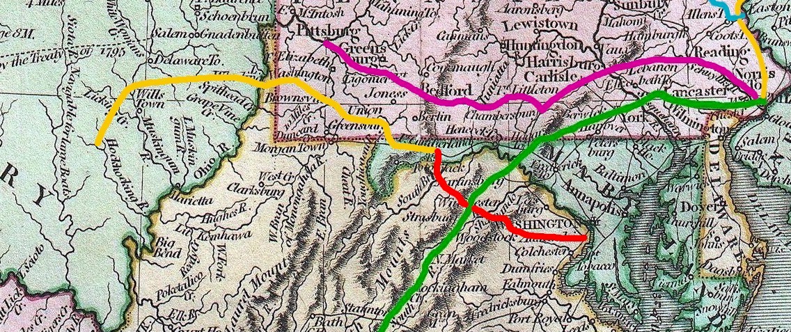
1. The Pioneer Road c. 1746
After 1716 and Governor Spotswood's expedition over the Blue Ridge, the people of Virginia sought a route to the west. But they weren't the first to settle there. Instead, a band of investors headed up by my ancestor Jost Hite and John Van Meter, the noted Indian trader, from western Pennsylvania were the first settlers west of the Blue Ridge. So the question is, "How did folks from western Pennsylvania wind up in the far west of Virginia?" And, the answer is, "By walking down the Great Wagon Road."
In 1731 Jost Hite and fifteen other families migrated en mass to the Shenandoah Valley of Virginia. The trip was slow and arduous; as they literally cut the road over which they drove their wagons. Arriving at Opequon Creek in what would become Frederick Co VA, they chose individual tracts on which they settled.
If you lived in the Tidewater of Virginia, you needed a road over the Blue Ridge and into the Shenandoah Valley. Thus in 1746, the Pioneer Road connected Tidewater Virginia and the King's Highway--the road that rose up from Williamsburg through Richmond to Alexandria--to the Great Wagon Road. providing direct access from the ports along the Potomac and lower Virginia to the Shenandoah Valley.
2. Extension of the Pioneer Road (Winchester to the Potomac c. 1755)
In 1754 Col. George Washington and the Virginia Militia departed from the Shenandoah Valley toward the Forks of the Ohio (Pittsburgh) on a mission for the Virginia Governor. Col. Washington, the great surveyor, was the perfect choice to blaze the new "military road." Note, this was not a road fit for wagons. but only a horse path. And, the new path would become known as the Washington Road.
En route, Washington "encountered" the French, a battle ensued, and Washington retreated to Ft. Necessity where he surrendered to the French. Good news: the original military path known as Washington's Road was opened towards the Ohio River. Bad news: Washington's faux pas "sparked" the French and Indian War in Colonial America.
With the onset of the French and Indian War in 1755, again Col. Washington and the Virginia Militia needed a road from the Shenandoah to Ft. Cumberland MD where they would meet up with British General Braddock en route to the Forks of the Ohio. And as Washington moved north and west to Ft. Cumberland, his troops improved the original military road. And over time with continuous traffic, Washington's military road became the extension of the Pioneer Road from Winchester to the Potomac at Ft. Cumberland.
3. McCullough's Trail c. 1756
 |
Prior to this research, the MuCullough Trail was unknown to me and probably most others. But in the early days of westward migration and prior to a lot of improvement to the Pioneer Road, McCullough's Trail was a primary route for my ancestors from the Shenandoah and the Lost/ Cacapon River Valleys of Virginia to Ohio and the American Northwest.
John McCullough of New Jersey migrated after 1752 to the South Branch of the Potomac in what is now Hardy Co VA. John McCullough isn't my ancestor or my relative. But, he lived next to several of my families in the South Branch of the Potomac River Valley.
The South Branch Valley lies approximately fifty miles from the Great Warrior Path, which runs north and south through the Valley of Virginia. White settlers used the Great Warrior Path, later the Great Wagon Road, as the main artery for traveling southwest and west from the eastern seaboard cities. The path ran from the home of the Iroquois in New York State south to the Carolinas. . .McCulloch’s (or McCullough’s) Path, or the Trader’s Trail, was used by Indian traders and was an important route west from the Great Warrior Path. It ran from the Great Warrior Path at Winchester through Wardensville in eastern Hardy County to the South Branch Valley at Old Fields. From Old Fields, it crossed the Seneca Trail and crossed the Allegheny Front to Mt. Storm. McCulloch’s Path turned north to western Maryland, finally extending west to the Monongahela Valley from which one could easily continue to the Ohio River and beyond. . .'The McCullough Trading Trail' led from the South Branch Valley through the Glades by way of the North Branch of the Potomac. George Washington, in his 1784 trip through the Potomac Highlands, followed it and described the Glades (pp 41-42):
John McCullough came from a Quaker community in New Jersey to the South Branch after 1752, although McCullough and his in-laws, the Inskeeps, were Presbyterians. They came to the South Branch together and settled at Old Fields. John McCullough’s sons, Samuel and John, were born in the South Branch Valley, and John McCullough first came to prominence during the French and Indian War as a trader. The McCullough family moved to the Ohio Valley circa 1772. (p 64)“These glades have a pritty appearance, resembling cultivated Lands & Improved Meadows at a distance; with woods here and there interspersed. . . . They are highly beneficial to the circumjacent Country from whence the Cattle are driven to pasture in the spring and recalled at Autumn.”
John McCullough, a resident of the South Branch near Moorefield, came to prominence with the Bouquet campaign [Pontiac's War, 1763 in Ohio]. McCullough was responsible for providing grain (“forrage,” or oats and Indian corn) to wagon trains when they reached the South Branch. In July, he accompanied Washington’s company as a wagon master from Pearsal’s Fort on the lower South Branch to Fort Cumberland. Washington recommended him to Henry Bouquet as someone “who would make an exceeding good Waggon Master.” McCullough was not primarily a farmer, as Henry VanMeter was, but a trader, and he obtained products, such as distilled spirits, beyond the primary agricultural goods (e.g., livestock and unprocessed grains). (p 124)
From: The History of West Virginia, Old and New, by James Morton Callahan, 1923, Internet archive
And, another record:
The seat of Hardy County was the town of Moorefield, which also was the heart of commercial agriculture in the county. The wealthy farms along the South Branch were close to Moorefield and Old Fields, and Moorefield had the advantage of being relatively well situated for overland travel. The McCullough trading trail, which led from Moorefield to Pittsburgh via the North Branch of the Potomac, was widened into a state route about 1785-86. (p. 176)McCulloch’s (or McCullough’s) Path, or the Trader’s Trail, was used by Indian traders and was an important route west from the Great Warrior Path. It ran from the Great Warrior Path at Winchester through Wardensville in eastern Hardy County to the South Branch Valley at Old Fields. From Old Fields, it crossed the Seneca Trail and crossed the Allegheny Front to Mt. Storm.
McCulloch’s Path turned north to western Maryland, finally extending west to the Monongahela Valley from which one could easily continue to the Ohio River and beyond. . . . (p. 41-42.)"Commercialism and the South Branch Valley, 1750-1800," West Virginia University Webpage <http://wvuscholar.wvu.edu:8881> 18 November 2014.
McCulloch's path, an early Indian and traders' trail
- westward from Winchester and Moorefield
- passed up Patterson's creek through Greenland Gap;
- crossed the Alleghenies at Mount Storm (in Grant county, West Virginia),
- led across Maryland on the general route of the Northwestern turnpike to the Little Yough near the route of the B. & 0. railway,
- across the Big Yough, through Herrington and Murley's Glades,
- via the Crab Orchard across the Pennsylvania line into Fayette county
- east of the summit of Laurel hill which it crossed at Wymp's Gap,
- thence (passing slightly north of Morris' Cross Roads)
- to McCulloch's old camp on the Monongahela between the mouth of Cheat and Neal's Ferry.
This trail was known to the people of the South Branch as early as 1756.
"Notes for McCullough's Trading Path," We Relate GenWebsite <http://www.werelate.org/wiki/> 19 November 2014.
4. Braddock's Road c. 1755
Before the French and Indian War, France not England explored but sparsely settled the lands north of the Ohio River which would become the Northwest Territory. Traveling along the many Indian Paths, a few French troops in the company of their many Native allies controlled the interior west of the Appalachians. If the British were to expand westward over the Appalachians, their army would need a route for re-supply and reinforcement.
Braddock's Road was built by the British Army and the Virginia Militia, including Col. George Washington during the 1755 campaign for Ft. Duquesne and control of the Ohio River.
Note: The original road was blazed by then Lt Col George Washington when the Virginia Militia marched in support of the new Ft Pitt, which was under construction at the Forks of the Ohio (now Pittsburgh PA). Washington never made it that far; as the Battle of Jumonville and the surrender at Ft Necessity fomented the ensuing French and Indian War.
As we know, the campaign started out as a failure; General Braddock and many of the British regulars were killed. But eventually, the campaign was a success. Why? The army had a pretty good road west over the Allegheny Mountains.
Braddock's Road ran from Willis Creek and Ft Cumberland, the head of navigation on the Potomac River. Heading first southwest and then northwest from Ft Cumberland, the road snaked through the Alleghenies to a crossing on the Monongahela River (vic. Brownsville PA) and then up the Monongahela to then French Ft Duquesne (now Pittsburgh PA).
The predecessor of this military road was called Nemaolin's Path, named for the Delaware Indian who assisted Colonel Thomas in blazing a path from Cumberland, Maryland to a trading post [operated by John McCullough of Frederick Co VA] of the Ohio Company of Virginia at present-day Brownsville, Pennsylvania. Soon after Virginia's governor [Dinwiddie] sent Major George Washington in that direction to expel the French from British territory. To accommodate his supply wagons, it was necessary to widen the trail, and that portion became known as Washington's Road. [Ft. Necessity Expedition 7/1754]Washington went with Britain's Major General Edward Braddock during the French and Indian War. A company of 600 soldiers set out from Ft. Cumberland to widen Washington's old road through Maryland, past the ruins of Fort Necessity on into western Pennsylvania, moving toward the French stronghold at the Forks of the Ohio, site of present-day Pittsburgh. [Braddock Campaign 7/1755]
Braddock's road was the first road to cross overland through the Appalachian Mountains. He insisted that the road be 12 feet wide so that horse-drawn wagons could travel on it to haul the necessary supplies for his advancing army. As the years advanced, Braddock's Road became impassable. Pioneers who trekked into western Pennsylvania usually preferred to depend on packhorse trails, traveling in caravans. When construction began on the new Cumberland Road, it roughly followed this old road. The Cumberland Road and its extension West became known as the National Road and now U.S. Highway 40.
"Braddock's Road," Early American Roads and Trails <http://freepages.genealogy.rootsweb.ancestry.com/~gentutor/trails.html> 16 November 2014.
5. The National Road c. 1806
The National Road was commissioned to connect the Valley of Virginia and the Potomac River Valley with the new settlements in Ohio. Starting at Cumberland MD, the head of navigation on the Potomac, the National Road followed the original route of Braddock's Road up through the Allegheny Mountains toward the intersection with the Monongahela River. At what is now Uniontown PA, the National Road spilt off heading west along the old Indian Path to Wheeling (W) VA.
The National Road is of great importance to our migration research; as this was the path over which our predecessors traveled from the Valley of Virginia into central Ohio. And, the 1806 date is also important; as prior to the National Road, earlier settlers would have had to walk along with their packhorses, following the old Indian paths.
6. Zane's Trace c. 1796
Zane's Trace was blazed by Col. Ebenezer Zane from the vicinity of Wheeling (W) VA west toward central Ohio. Completed in several sections. the road extended through Zanesville OH to Lancaster in present day Fairfield Co OH by 1800. Future sections of the road wound south and west to the Ohio River at Maysville KY. And, even later sections continued south to connect Ohio with Lexington KY and eventually Nashville TN. But, the original two sections definitely preceded the National Road.
In 1796 Colonel Ebenezer Zane petitioned Congress to authorize him to build a road from Wheeling to Limestone [now Maysville KY]. Congress awarded him a contract to complete a path between Wheeling and Limestone by January 1, 1797. The contract required him to operate ferries across three rivers as soon as the path opened. His only compensation was to be three 640-acre tracts, one at each river crossing, to be surveyed at his own expense.Zane rounded up equipment and a crew of workmen; with axes, they cut trees and blazed a trail. At first, Zane's Trace was merely a narrow dark path through the forest, between a wall of ancient trees. Only horsemen could travel over it. For many years, it was not wide enough for wagons. In 1804 the Legislature appropriated about fifteen dollars a mile to make a new twenty-foot road over Zane's route. But by modern standards, it was still a poor road because they left tree stumps whenever they were one foot high.
The Trace was used by hundreds of flat-boatmen returning on foot or horseback to Pittsburgh and upriver towns from downriver ports as far away as New Orleans. The road also became the mail route from Wheeling to Maysville, and eventually it went on to Lexington and Nashville.
"Zane's Trace," Early American Roads and Trails <http://freepages.genealogy.rootsweb.ancestry.com/~gentutor/trails.html> 16 November 2014.