This map project on the Roads and Trails of
Colonial America started by questioning what routes the immigrant ancestors
used during their southern and western migrations. The assumption was that our
earliest immigrant ancestors were limited to the waterways which accessed the
coast and an occasional Indian path. And for the most part, that was true,
However, further research proves that the Native population used trails and
routes extensively to travel and trade throughout the hinterland and even to the
coast. The challenge was for our early ancestors to identify the many routes and
survive the journey.
The following chart is a graphical compilation of the many
migration routes my ancestors followed and is divided into five sections, north
to south.
Overview: Taken in total, the map displays the route of the Great Wagon Road and
the many intersecting routes by which our ancestors accessed the interior of the
continent. The Great Wagon Road, highlighted in green, ran from
Philadelphia to the Susquehanna Valley, across the Potomac, up the Shenandoah to the Valley of Virginia,
then up again to the Carolina
Piedmont and then down to Ft. Augusta GA on the Savannah River.
#1. Migration from the frontier of New York to the frontier of
the Delaware Valley:
-Beginning in the late 1600s in Dutch America/ New York, my Dutch, German,
French Protestant ancestors migrated south down the Old Mine Road to the
frontier at Minisink on the Delaware River.
-From the northern Delaware Valley, my German ancestors migrated west on Owens
Road to the Susquehanna River and later migrated west on Forbes Road
across Pennsylvania and then down Zanes
Trace to central Ohio.
#2. Accessing the Interior by the National Road:
-Beginning in the early 1700s, my German ancestors migrated from
the Port of Philadelphia west down what would become the Conestoga Road to
Lancaster in the Susquehanna Valley.
-From the Susquehanna Valley, my German ancestors migrated south and west down
the Great Wagon Road to the Shenandoah Valley.
-From the Shenandoah and Lost River (W) VA, my German ancestors migrated west on
the Cumberland/ National Road to central Ohio.
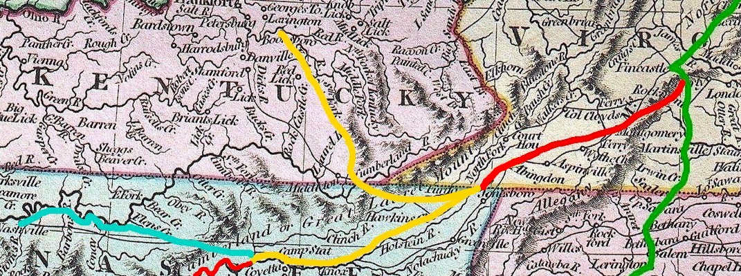
#3. Accessing the Interior by the Wilderness Road:
-Beginning in the early 1700s, my Scot ancestors migrated south from Virginia on
the Great Wagon Road to the Piedmont of North and South Carolina and even
Ft. Augusta GA.
-Beginning in the mid 1700s, my Welsh/ Scot/ Irish ancestors
accessed the Interior from the ports of Virginia and Maryland by way of the
Pioneer Road.
-After the Revolution, my Irish ancestors migrated south down the Great Wagon
Road to the Wilderness Road and the frontier of Kentucky and Tennessee.
#4. Cherokee Passports and the Unicoi Trail:
-From the 1790s to about 1810, what we know as Georgia was limited primarily to
the settlements along the Savannah River. Lacking infrastructure and possessing
great expanses of land, there were few routes into Georgia.
-Migrating south out of Virginia, my Lewis ancestors traveled the Wilderness Road
to the headwaters of the Holston River and down to Ft. Southwest
Point TN where they obtained Cherokee Passports to traverse Cherokee Territory.
From Ft. Southwest Point, they took the Tennessee
River south to the confluence with the Hiwassee River. Here they entered the
Cherokee Nation.
-From the Tennessee, the Unicoi Trail traveled up the Hiwassee through
the narrow passes of the Smoky Mountains,
then up again into northern Georgia to Unicoi Gap, then finally down the
headwaters of the Chattahoochee River to Jackson Co GA.
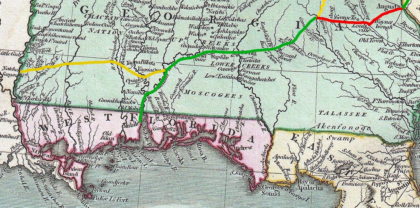
#5. Choctaw Passports and the Three-Chopped Way:
-By the 1810s, my Scot families of the Carolina Piedmont continued their
migration south to the Great Wagon Road's terminus at Ft. Augusta GA.
-Traveling the poor roads of Georgia, they arrived at the new capitol of
Milledgeville where they obtained Choctaw Passports to traverse the Choctaw
Nation.
-From Milledgeville, they migrated west on what would later be named the Post
Road. They entered Choctaw Territory when they crossed the Chattahoochee
River at Coweta GA.
-Traveling west, the Post Road intersected with the Alabama River and
wended south toward Mobile (AL).
-At Old St. Stephens (AL), the Three-Chopped Way took my family west to the
Chicasawhay River settlement in eastern Mississippi during the outbreak of
"Mississippi Fever."